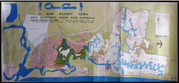
This beautiful map dated 1975 illustrates the achievements of Princess Properties after only six years. The map shows the completed Stage 1 and part of the Stage 2 canal development. The town complete with all services. The planning was the work of Prof. Robert Sully of California USA.
click here to access images of the Ocean Shores Development in the late 1960’s
Some of the features illustrated in the 1975 map are:
- The Roundhouse: Opened 29th March 1969. The iconic 1.2 Ha 360 degree view site on which the sixteen sided Administration Building and Art Gallery was built. It was designed by Robert Sully to be demountable and intended to be moved to North Ocean Shores when Stage 3 commenced. (building demolished by council in 1996. Stage 3 was subjected to political intervention and prevented from proceeding. Almost 1000 Ha of the Stage 3 land is now the Billinudgel Nature Reserve.)
- The Ocean Shores fully operational 18 hole Golf Course designed by Australian Bruce Devlin and USA Golf Architect Walter von Hagge.
- The lakes system on the golf course plus Lake Balemo and Waterlily Lake. The lakes were designed to provide flood storage to protect low lying areas.
- The Ocean Shores Country Club.
- The Orana Apartments.
- The Orana Bridge linking the town to the beach, New Brighton and South Golden Beach.
- The Billinudgel Industrial Estate on the eastern side of the railway line and village.
- The Tyagarah aerodrome now owned by the council.
- The Rajah Road shopping centre designed to be small and local.
- Two shopping and business centres were planned for Stage 3 of the development, as was a high school, town centre, two primary schools, sportsfields and more. (see white areas of the map – future planning.)
- Shara Boulevarde southern end constructed. In Stage 3, the northern section to extend north to Wooyung Road and coast road to Tweed Heads.
- Streets designed to follow contours of the land.
- Underground power, water and sewer, telephone services. No telegraph poles.
- Traffic roundabouts on Orana Road and Rajah Road connecting traffic to the old Pacific Highway plus a small roundabout at the junction of Orana and Warrambool Roads.
- Sales centre at Orana Road/Balemo Drive entrance to the town, now the Ocean Shores motel.
- Open community parks including Yallakool, Goondooloo, Waterlily parks and Marshalls Creek public open space park alongside river and shopping centre now a nature reserve with restricted public access.
- Capricornia Canal with flood outlet to the ocean, later ordered closed by council.
- Capricornia Canal development.
- Shara Boulevarde (southern end) , Banool Circuit, Kallaroo Circuit and Kolara Way major roads constructed for Stage 2 of Ocean Shores, plus infrastructure, roads etc.
- $1 million bond lodged with Byron Shire Council for construction of a bridge over the Capricornia Canal on Kallaroo Circuit.
- Council instead built an earth bund, and eventually had to refund the bond for failure of contract.
- Approximately 2000 fully serviced building lots.
- Covenants to protect residential dwellings from over development, eg one dwelling per site, height restrictions, 6 metre setbacks from street, 3 metre setbacks from each house, no front fences etc. NSW Planning has since overridden most covenants.
- Land zonings included residential, commercial, medium density, industrial, open space and recreational.
- The white areas of the map show areas for future development, as of 1975 uncompleted planning.